Your support helps us to tell the story
My recent work focusing on Latino voters in Arizona has shown me how crucial independent journalism is in giving voice to underrepresented communities.
Your support is what allows us to tell these stories, bringing attention to the issues that are often overlooked. Without your contributions, these voices might not be heard.
Every dollar you give helps us continue to shine a light on these critical issues in the run up to the election and beyond

Eric Garcia
Washington Bureau Chief
A powerful typhoon has lashed the Philippines and is now churning towards Taiwan, prompting warnings and flight cancellations.
Krathon has been upgraded to a strong typhoon, with sustained winds reaching up to 175 kmph (109 mph) and gusts as high as 215 kmph (133 mph).
The slow-moving storm was blowing westward and could strengthen into a super typhoon when it veers northeastward on Tuesday towards Taiwan.
Taiwan issued a land warning this morning as forecasters warned the storm is expected to cross the island’s densely populated west coast, including the major port city of Kaohsiung, bringing torrential rain and strong winds.
“The impact is getting bigger and bigger,” said Gene Huang, forecaster at the CWA, pointing to threats to Taiwan’s southwest and adding it was “rare” for such a powerful typhoon to make a direct hit on the island’s western plains.
The storm has already lashed the northernmost islands of the Philippines, prompting officials to evacuate hundreds of villagers, shut down schools and inter-island ferries and warn of “potentially very destructive” rainfall in the region.
Photos: Taiwan braces for Typhoon Krathon


Stuti Mishra30 September 2024 08:45
Typhoon Krathon tracker: Path and forecast
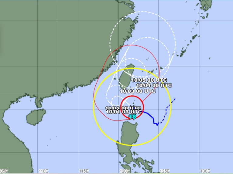
Typhoon Krathon is currently tracking west-northwest toward Taiwan after impacting the northern Philippines.
Krathon is classified as a “very strong” typhoon, with maximum sustained winds near the centre reaching 185 kmph and gusts of up to 260 kmph, according to the latest updates from the Japan Meteorological Agency (JMA) and Taiwan’s Central Weather Administration (CWA).
Currently located approximately 430 kilometres southeast of Taiwan’s southernmost point, Oluanpi, the typhoon is moving west-northwest at a slow speed of around 10 kmph.
Krathon is expected to continue moving westward before turning slightly northwest and making landfall near Kaohsiung, Taiwan, by late night tomorrow or early morning on Wednesday. Winds are expected to reach up to 185 kmph (115 mph) near the centre, equivalent to a Category 4 hurricane on the Saffir-Simpson scale.
Following landfall, Krathon is forecast to move across southern Taiwan, bringing heavy rainfall, intense winds, and a high risk of flooding.

Stuti Mishra30 September 2024 08:23
Typhoon Krathon set to make rare landfall on Taiwan’s populated west coast
Typhoon Krathon, a powerful storm that has already lashed the northern Philippines, is now heading toward Taiwan, bringing the potential for destructive winds, torrential rains, and severe flooding.
The Japan Meteorological Agency (JMA) has classified Krathon as a “very strong” typhoon with sustained winds of 95 knots (109 mph) and gusts of up to 135 knots (155 mph).
It is expected to strengthen further as it approaches Taiwan’s heavily populated western coast tomorrow.
Taiwan’s Central Weather Administration (CWA) has issued land and sea warnings as the typhoon draws closer.
The storm is forecast to make landfall near Kaohsiung, Taiwan’s major southern port city, late Tuesday or early Wednesday.
“The impact is getting bigger and bigger,” said Gene Huang, forecaster at the CWA, pointing to threats to Taiwan’s southwest and adding it was “rare” for such a powerful typhoon to make a direct hit on the island’s western plains.
Stuti Mishra30 September 2024 08:16
Typhoon Krathon lashes Philippines
Typhoon Krathon, locally known as Typhoon Julian, has battered the northernmost islands of the Philippines, prompting widespread evacuations and warnings of potential devastation to coastal communities.
The powerful storm, with sustained winds of up to 109 mph and gusts reaching 133 mph, was last located near Balintang Island, off the provinces of Cagayan and Batanes, according to the Philippine weather bureau PAGASA.
The slow-moving typhoon is expected to strengthen further, potentially reaching super typhoon status as it turns northeast towards Taiwan tomorrow.
Although no casualties or significant damage have been reported so far, officials remain on high alert as the storm poses a significant threat to lives and infrastructure.
Hundreds of villagers were evacuated, schools were shut down shut down schools and inter-island ferries were closed.
PAGASA has issued warnings of a “moderate to high risk of life-threatening storm surges” along the coastal areas of Batanes, Babuyan Islands, and Cagayan province.
“The situation is potentially very destructive to the community,” it said.
Stuti Mishra30 September 2024 08:00
Welcome to The Independent’s liveblog on Typhoon Krathon. Follow for the latest updates from the Philippines and Taiwan.
Stuti Mishra30 September 2024 07:48

